Greenlee County
Points of Interest
Apache-Sitgreaves National Forest
Restful, solitude with excellent camping, fishing (trout and catfish), and hunting (mule and white tail deer, turkey and elk and bear) on the Apache Sitgreaves National Forest. The altitude ranges from 6,700 to 8,700 feet. Drive the scenic trail (U.S. 666) blazed by Coronado in 1540. Stay at the Lodge at Hannagan's Meadow. Back pack into the Blue Range Primitive Area. (Ask for the Office of Tourism's Recreation map of the area.)
Coronado Trail
The Coronado Trail follows essentially the same path the Spanish conquistadors traveled in search of the Seven Cities of Gold. The road winds approximately ninety miles from 3,500 feet to 9,300 feet. The majestic vastness here is still as untamed as it was in Coronado's day. If his search for gold was fruitless, it was rich in scenic splendor. The varied landscape of Greenlee County has two basic climatic zones: the desert basin and range lowlands in the southern half, where mesquite grass, yucca, creosote and salt bush grows; and the wooded highlands and mountains in the north, a land of yellow pine, douglas fir, alpine flowers, bear, mountain lion, wild turkey, elk, and other wildlife.
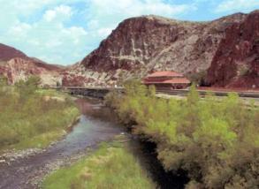
Photo by Don Lunt
Fishing / Hiking / Hunting
For the fisherman, hunter, and hiker the value of the area is quickly apparent. Fish in one of the several rivers and creeks that yield a variety of trout and catfish, these rivers provide many recreational opportunities. Black River has rainbow trout and Arizona rainbow trout, trout and catfish can be found in Eagle Creek, rainbow trout can be found in the Blue River. Many find pleasure fishing for catfish in the Gila River and San Francisco River. There are excellent dove and quail hunting in the Duncan Valley. Mule and white tail deer, turkey and bear can be found in the Apache-Sitgreaves Forest.
Rock Hunting
Within the County can be found a treasure chest of semi-precious gems and minerals. It is perhaps one of the richest collector's field in the Southwest. Limestone Canyon, northeast of Clifton, is one of the world's largest deposits of agate, blood red jasper and steel gray rhyolite. Malachite, azurite, and chrysocolla can be found in the Morenci area, and chalcedony and fire agate south of Duncan.
Farming / Ranching
With both cattle ranching in the forest and irrigated farming in the lower elevations near the Gila, agriculture is an important industry in Greenlee, but copper mining is by far the leading industry and economic base.
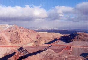
Photo by Don Lunt
Freeport-McMoRan
The open pit mine is rich in copper and has an exciting history which mirrors the development of the West. It would be impossible to write the history of Arizona without including the colorful chapter on mining. The history of Arizona is etched with tales of gold, silver and copper. Today about one of every eight jobs in the state depends on the copper mines. Tax revenues generated directly and indirectly by Arizona's copper mines amount to about one of every four dollars paid to state and local government.
Clifton and Morenci were practically isolated from the rest of the world before 1882. The only way of transporting people and materials to and from the area was by wagon train, which were often raided by the Indians. The constant raids strongly influenced the decision to build the area's first railroad. Those pioneers could not even imagine the type of technology that is now used by Freeport-McMoRan. They would be completely amazed by the open pit operations. Here the world's largest copper ore concentrator produces more copper in a single shift than the men of their era could have mined in a lifetime. Today the Morenci mine produces more copper than any mine in North America. Ore has been taken from this mine for well over 130 years. The open pit is the 2nd largest in the world and one of the most efficient and modern mines in the world, and continues to be a major economic factor in Arizona's economy and future.
The Morenci Branch of Freeport-McMoRan is located in Morenci, Arizona. The open pit copper mine was developed more than 50 years ago when a small amount of ore mining commenced for testing purposes. As late as 1930 mining was done by underground methods. The operation was closed in 1932 because of the great depression. In 1937 development work started for the Morenci Open Pits mine, 50 million tons of material were removed in the initial development. The waste was dumped into Fairbanks Canyon, north of the pit, and later into the Coronado Canyon. The colorful terraced Morenci mine is a spectacular sight, and is in a class by itself. It is composed of a series of enormous open pits covering an area about two miles wide by five miles long.
The mine also has a concentrator, a leaching and precipitation plant, a Solvent Extraction Electro Winning plant which extracts copper by a clean, cost efficient method, and many support facilities. The operations are worked annually, 24 hours a day, seven days a week. The Morenci SX/EW Plant can produce over 500 million pounds of 99.99% pure copper annually. The mine moves 835,000 tons of material to produce three million pounds of copper daily. Throughout the process Freeport-McMoRan takes great care to protect water, land and other natural resources.
No 5 Baby Gauge Locomotive
The 'No. 5' baby gauge locomotive was used in Metcalf in the early 1880's. These marvelous little machines, represented the cutting edge of mining technology in the late 19th and early 20th centuries. This train was manufactured by the H.K. Porter Company of Pittsburgh, Pennsylvania. This locomotive was probably pulled up the incline, possibly in parts, and assembled on top of the mine site. It was used to transport ore from the Matilda Shaft on Coronado Mountain to the top of the terrifying steep Coronado incline which was 3,300 feet long and 1,500 feet high. The mine shut down in 1923, the 'No. 5' and two other locomotives were stranded for 67 years on short lengths of tracks on the virtual inaccessible mountain. Souvenir seekers took the bells, whistles, the brass builders plate and the road numbers (the number on the front of the engine.) There was no way of identifying the locomotives from the remaining physical evidence. Over the years, many attempts were made to remove the three engines from their mountain hide-away, but none were successful until March 1990. A drill road (which was very steep and had a lot of switchback) was built to accommodate drilling equipment to define an important ore body for future mining. Under the responsibilities of Ted Cogut and the direction of Jack Cooper, the three engines were brought down on March 1990 by the surface department on a low-boy truck and driven --- very slowly --- down the mountain. In places where the road was extremely steep, the flat bed was lowered down the mountain by means of a cable attached to a trailing dozer. They were stored temporarily in the Surface Department yard until they could be restored. An important piece of evidence was discovered in the Freeport-McMoRan Morenci Photography Department which would help in the restoration of one of the engines. A glass plate negative was found, taken about 100 years ago, of one of Arizona's Copper's baby-gauge locomotive which was used in Metcalf and showed the engine's road number, the No. 5. Through this old photograph and after close examination of the rivets and bolts, they can identify one of the three locomotives that had been resting on the Coronado Mountains as No. 5. They couldn't tell what was on the builders plate, so a part of the old photograph was enlarged to show the engine's serial number and 1888, the year it was manufactured. The name of the superintendent of the Porter Locomotive Works, which was on the builders plate was not clear. After extensive research they could get the name of the superintendent which perfectly matched the few letters that appeared in the enlarged photograph. CEMCO Manufacturing in Albuquerque, New Mexico restored the No. 5 to look as it did when it was rolled out of the H.J. Porter Factory in Pittsburgh more than a century ago. It was complete with a whistle, brass bell, and a historically accurate brass builder's plate. The 'No. 5' was put on display in the Morenci Plaza on January 18, 1991. The 'No. 7' is on display at the Museum of Discovery in Safford and the 'No.' 2 is on display at the Mining and Minerals Museum in Phoenix.
Old Catholic Cemetary
Going up to the Coronado Trail is the site of the old Catholic cemetery. Across from it is the road leading to lower Eagle Creek. The old Catholic Cemetery is all that remains of old Morenci. The rest of the town was either blasted away in the expansion of the open pit mine, or has been buried under mine waste. In 1983, Tony Enrico, a field surveyor for Phelps Dodge, said the cemetery would not be disturbed because 'the surface indications show there is no mineralization of value there.' Some burials go back to 1881, but no one has been buried there since the 1930's. The cemetery was about one and a quarter miles from old Morenci, and since there were no roads to it, you'd see 50 to 60 men lined up behind a coffin, taking turns carrying it to the cemetery.
Most of the graves were blasted with black powder. 'They'd make a hole, and lay a template over it in the shape of the coffin to see if the box would go down without getting stuck.' During World War I, an influenza epidemic claimed the lives of many babies. Families would take the small victims to the cemetery at night and bury them in the narrow spaces near their kin.
Another cemetery was located in old Morenci next to the Arizona Central underground mineshaft. If someone died in the mine, he'd be brought out and placed in coffins stored there. There was a window in the box. No embalming was done. The family was called and they would stand the coffin up to have their last picture taken with the deceased. Then they'd bury him. This created a problem once. Two men were courting the same girl and she married someone else. A jilted lover committed suicide and his family wanted his former girlfriend, now married, to have her and the other jilted suitor's pictures taken with the deceased. They stood the coffin up on a chair, but a big wind came along and knocked it over. After that, the superstition grew that the suicide victim would never rest until the other jilted suitor was dead.
This and another cemetery have been moved. The cemetery at the Metcalf mine, just north of old Morenci, was moved to Clifton in 1948. The graveyard at the Arizona Central shaft in old Morenci was moved to East Plantsite in New Morenci in 1951.
Clifton
Clifton is the county seat of Greenlee County. The Town of Clifton is set in a rugged mountain canyon, which has been formed by the San Francisco River. The date of 1873, is set as the founding of Clifton, the year the Lesinsky brothers built a smelter at Clifton because it was close to water. The name of the town has two different stores of origin. An early pioneer in the area was Henry Clifton, and some say it is his name which was given to the town. Others say it is a contraction of “Cliff-Town” which is an adequate description. It was formerly the mining center of Greenlee County, but has been supplanted by Morenci. Clifton, meanwhile has developed into an area trade and center. It houses various state, federal, and county offices. It is the southern terminal of the Colorado Trail and the “Gateway to the White Mountains.”
Smelter Hill
Driving into Clifton one can't help noticing the remains of an old smelter. This smelter was started in January 1912 and the first copper was poured on October 8, 1913 by the Arizona Copper Company. It replaced a still older smelter whose ruins can be seen behind the Circle K in Clifton. By 1929 the Clifton Smelter was producing nearly 55 million pounds of copper per year. When underground mining ended in Morenci in 1932, the Clifton smelter was shut down. It was reopened in 1937 and 1938 to smelt concentrates shipped in from Bisbee, but was soon shut down and dismantled never to be opened again.
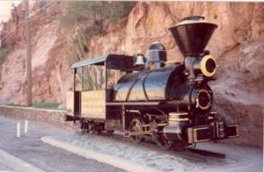
Photo by Don Lunt
Copperhead Train
Arizona's first narrow gauge railroad was built by the Lesinsky brothers to bring ore from the Longfellow Mine five miles up the canyon to the Chase Creek smelter. Initially, mules pulled ore cars up the hill, and rode down as passengers on the loaded ore cars which were moved by gravity, braking was controlled by a “motorman.” Ore was delivered into bins still visible today, behind the Circle K store. (The white pipeline running against the bluff is laid on the trackbed of this railroad.)
From 1880 to 1899, ten 20-inch baby gauge locomotives were purchased from the H.K. Porter Co. of Pittsburgh and delivered to railend at La Junta, Colorado. (They were called baby gauge because the track is only 20 inches wide, whereas a narrow gauge is 36 inches wide and a standard gauge is about 58 inches wide.) From there the first one, the “Emma” was transported to Clifton by ox team by Charles Stevens. This was the first baby-gauge locomotive to arrive in the Territory of Arizona. One Porter locomotive, made in 1897 was named 'Number 8' on the company records, and nicknamed “Copper Head.” The Copper Head was used on the mining properties at Metcalf, several miles north of Clifton, the engine was retired in 1922. The locomotive is on display thanks to Tom Sidebotham, a long-time resident of Clifton, who used to be an engineer on the Coronado Railroad. He recovered the “Copper Head” from a junk dealer who was hauling it to his scrap yard in Tucson. He rebuilt it from parts of several engines and painted it. It has stood in the Clifton Plaza since 1937 and can still be seen in front of the Clifton's Original Cave Jail.
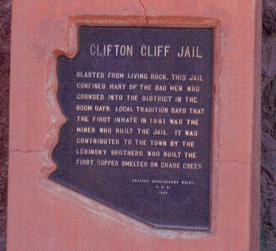
Photo by Don Lunt
Clifton Cliff Jail
The old Clifton Jail, a rock bastille blasted out of the side of the mountain was built in 1878. Many of the West's real badmen were incarcerated in it at one time or another. It is one of the State's most famous jails.
It was contributed to the Lesinsky brothers, who built the first copper smelter on Chase Creek.
Before the building of the jail, evildoers were punished by being sentenced to work in the mines. Many of them escaped before they completed their sentence leaving the county. The Lesinskys decided to have a jail built to hold them.
The job of cutting the stone jail was given to Margarito Varela, a stone worker. Varela worked away at the face of the cliff with pick and drill and blasting powder. A small room was made to hold the more dangerous criminals. A larger one, 8 feet wide and 20 feet long was built for those whose offenses which were of a milder nature. Both of the cells were fitted with massive iron bars which were 2 inches wide and 3/4 of an inch thick. The doors were of the same material, pivoting on two-inch solid iron rods. The two windows of the jail were 10 feet above the floor. Although it didn't look like much, it was absolutely escape-proof. It was said that no men ever escaped from the jail.
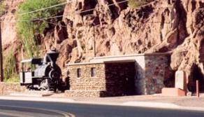
Photo by Marilyn Alvidrez Varming
Tradition says that when Varela finished his job he decided to celebrate. Varela invested his profits in snakehead whiskey. He was so happy that the jail was finished he pulled his gun and proceeded to shoot up Hovey's Dance Hall to attract the peoples attention and to tell them the jail was finished. The proprietor of the salon was also the deputy sheriff and arrested him. Varela became the first guest in his own jail.
The old stone jail was the Town of Clifton's only bastille for many years. When the jail was first built, it was higher than the town and was approached by climbing up the mountain to enter it. Sediment from subsequent floods gradually raised the ground level even with the entrance to the jail. The great flood of 1906 flooded the jail to a great depth, and the prisoners were taken out by ropes through a small window high up in the roof. That was the last time the jail was used. It soon became filled with mud and debris. In 1929 Mayor Peter Riley of Clifton started a movement to have the old bastille restored.
Chase Creek
Chase Creek was once the center of a bustling 1800's mining community. The origin over the naming of the street is almost as interesting as the history of the area itself. The name came about because of an incident in Silver City, New Mexico, in 1872. According to legend, the Apache tribe struck during the night and made off with the best horses in the Valley. Groups of Calvarymen were put together and sent out in hot pursuit. That group was headed by Captain Chase and in the group were the soldier-prospectors Jim and Bob Metcalf. The trail led down the Gila River to the San Francisco River through a narrow canyon into the pines. While passing through the canyon, the Metcalfs noticed rich copper deposits in the walls. The troop was never able to find the Apaches, but on the return trip, the Metcalf and other soldier-prospectors staked a claim. The Metcalfs named their claim Longfellow, since it was found on the poet's birthday. The canyon was named for a young calvary captain, and later a town in that canyon was named for the two soldier-prospectors. (The Town of Metcalf is now buried a few miles up Chase Creek.) When the Town of Clifton was finally developed, that main business street was called Copper Avenue, but nobody used that name, everyone called it Chase Creek.
In 1908 Chase Creek begun a boom that was to continue for twenty years. The only drawback was that Chase Creek proved to be a slumbering giant, awakening occasionally in great floods. Streets were still dirt and seldom graded except after floods, some property owners built as high as three feet above the street to protect themselves from floodwaters. Flooding was always an ever-present source of danger.
The Chase Creek dry wash was formed by numerous floods. The floods of 1903 and 1906 almost washed part of the town away. In the 1890's, the Arizona Copper Company tried to contain runoff by pouring molten slag from the company's smelter along either side of the channel. Subsequently, in about 1902, walls were erected on the stable, black slag foundations. Tuff stone for these walls was obtained from a quarry visible today high on the opposite canyon wall.
The wash also served a second function: ranchers were now able to drive their cattle to market without going through the business district street. The largest drives originated at Houx's Double Circle Ranch (423,000 acres with 20,000 cattle, 350 saddle-horses and 25 cowboys). Thousands of cattle were taken through this channel to the riverbed below, then to the stockyards south of town where they were loaded onto railcars bound for Chicago slaughterhouses. The event was a delight for the children who lined Chase Creeks walls to watch cowboys and cattle pass below.
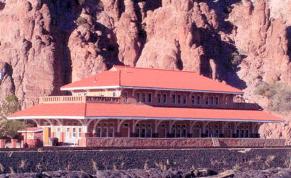
Photo by Don Lunt
Arizona and New Mexico Railway Passenger Station
The station is a highly visible landmark in Clifton. This railroad station was an unusually large railroad station for a town the size of Clifton. Completed in October, 1913, the two-story brick station was built in anticipation of a population growth of 20,000 people which never materialized.
It was used as a restaurant for a number of years and then left vacant for a number of years where it was deteriorating from flooding, vandalism and neglect. The station was deeded to the Town of Clifton by the Southern Pacific Railway in 1989, where it was renovated by the Town of Clifton and used as a town facility. The building was constructed of brick with durable and permanent finished in the lower story, which made it somewhat resistant to the floods which washed through Clifton periodically. In order to erect the new station the Arizona Copper Company had to construct a ten-foot high slag wall along the east side of the San Francisco River and fill it with earth brought in from the mountains. The cost of the building is estimated at $35,000. The first floor contained a waiting room, a private ladies waiting room, a ticket office, a baggage room, and an express office for Wells Fargo, a janitor's room, and office for conductors and restrooms. The second floor contained the offices of the superintendent and his staff, the office of the assistant engineer and the offices of the yard and train masters. In the early 1920's the mining companies shut down their operation due to the sharp slump in the copper market. One thousand Mexican nationals left Clifton-Morenci district by train to El Paso and back home. By the 1930 Clifton's population sagged and economic conditions continued to get worse. In 1932 Phelps Dodge announced a complete shutdown at Clifton-Morenci for at least two years. Once again many said goodbye to their friends and boarded the train bound for Lordsburg. It was undoubtedly one of the last major events witnessed by the stately station while still officially chartered as a passenger depot. On August 1932 the railroad station was moved to the freight station. What had begun with such high hopes just twenty years before now succumbed to the economic woes of the Great Depression.
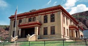
Photo by Don Lunt
County Courthouse
The location of the County Courthouse in Clifton was surrounded in controversy. Henry Hill and others wanted it placed in South Clifton arguing that it would always be above flood there. Jim Hagan, S.F. Awalt, and O.A. Risdon wanted it in the Eastside because it was the most important part of the town at that time.
Those who wanted it in South Clifton were said to have won the election to decide on the location by promising to give the ground on which the courthouse was built to the County. Later when Henry Hill sold the lots to the Board of Supervisors, A.T. Thompson got an injunction to stop building saying that Hill had originally promised to give the lots to the County. The suit was dismissed on grounds that such a verbal agreement had no standing in the eyes of the law. The Courthouse was built on five lots sold to the county by Hill. F.C. Heck was the architect and Otto P. Koreger was the contractor. The original cost of the building was $43,000 which included the County Jail that was built adjacent to the courthouse. Building was started on January 1, 1911 and the new county offices moved into it September 1, 1912, although it wasn't quite finished. The first county election in Greenlee County was held in 1910. The Courthouse has been used continuously since it was built, except when the building was being renovated in 1998. On August 10, 1998 the renovated courthouse was dedicated and the offices were moved back in.
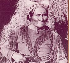
Photo from Greenlee County Historical Society
Geronimo
The worst Indian outbreak for Clifton was that of Geronimo. Geronimo himself said his birthplace was near where Clifton now stands. He left the reservation in the spring of 1882, with some two hundred young warriors. He raided an area about 500 miles in diameter around Clifton for the next four years.
Soon after the outbreak started, a band of men left Clifton for Gold Gulch northwest of Clifton, on what is located on lower Eagle Creek Road. They were attacked by the Apaches. Four men were killed; Captain Slawson, J.R. Risque, and two others whose names were unknown. Captain Frink, who was with the party, escaped by falling and rolling under some mesquite bushes.
An ore train traveling from Morenci to the Detroit Company's smelter 2 miles below Clifton on the river was attached by the Apaches the same day. The drivers were killed and the mules taken. They proceeded onto the river and attached the smelter. The men inside returned the fire of the Indians and the braves left after firing a few shots at Mr. Church's house.
The next morning, a wagon train, returning from Lordsburg, loaded with flour and supplies for the store at Clifton, was attacked. The Apaches rode up as they were breaking camp at Guthrie, 12 miles from Clifton, on the Gila River. They claimed to be scouts. Not knowing that an Indian war had broken out, they let the Indians get between them and their guns. All the Mexicans were killed except one, who was gathering the mules. They took all the supplies and guns and rode on up the Gila Valley.
They then attacked the York ranch, but were driven off. The Apaches, not caring for an attack that was not quickly won by surprise, rode off toward Carlisle, but left some of their braves lurking nearby. York rode out to trail some of his horses the Indians had driven off and was ambushed and killed.
A troop of United States Calvary was sent to Clifton, but by the time they arrived, the Indians were a hundred miles away, raiding the Silver City area. Twenty-five people had been killed within a fifteen-mile radius of Clifton.
Although Geronimo raided another 4 years over Arizona and New Mexico, he didn't make any further prolonged stays in the Clifton area.
In 1886, he was persuaded to surrender by Lieutenant Gatewood and was sent to Florida along with many Apaches. Later they were taken to Fort Sill in Oklahoma where he lived until his death in 1909, never to return to Arizona.